Exploring Cape Reinga: Where Two Oceans Meet
Cape Reinga is one of the most powerful NZ road trip destinations; it combines sweeping lighthouse views, the visible meeting of the Tasman Sea and Pacific Ocean and deep Māori spiritual significance at Te Rerenga Wairua, the leaping place of spirits. With Te Paki Sand Dunes, Ninety Mile Beach and remote Northland scenery close by, it deserves at least a full day from the Far North or a multi-day loop from Auckland or Whangārei in a RaD Car Hire rental.
Why Cape Reinga matters so much
Cape Reinga sits at the very tip of the Aupōuri Peninsula and is home to New Zealand’s northernmost lighthouse station, perched above steep cliffs and swirling seas. The Māori name, Te Rerenga Wairua, means the leaping off place of spirits; oral traditions say the spirits of the dead travel the length of the North Island to this point, then depart the physical world.
Visitor numbers have grown steadily, with estimates of more than 500,000 people a year making the journey north, helped by the sealing of the road all the way to the car park. That mix of accessibility and cultural weight makes Cape Reinga one of the most significant NZ road trip destinations for both domestic and international travellers.
RaD Auckland Airport tip: If you are flying into Auckland and heading straight north, aim to overnight in Paihia, Kerikeri or Kaitaia then do Cape Reinga as a relaxed full day loop. This keeps your first driving day shorter and lets you time your visit for calmer morning light at the lighthouse.
Read more: 10 Top Destinations Within a 3-Hour Drive of Auckland
Where the Tasman Sea and Pacific Ocean meet

From the viewing area below the Cape Reinga Lighthouse, you can often see two different water colours and surface patterns colliding offshore; this is where the Tasman Sea and Pacific Ocean meet in a visible clash of currents and swell. The turbulence creates standing waves, swirling lines and white streaks that look almost painted on the surface of the water.
In Māori tradition this meeting of waters is known as Te Moana a Rehua and is sometimes described as a male sea and a female sea coming together - a symbol of energy, balance and new life. For many visitors, watching the tides race each other beneath the cliffs while standing in a strong breeze becomes one of their standout New Zealand memories.
RaD Whangārei staff tip: Check the weather before you lock in your Cape Reinga day - clear or partly cloudy days give the best colour contrast between seas, but even moody overcast conditions can make the waves and currents look impressively dramatic.
The lighthouse and walking tracks
Cape Reinga Lighthouse
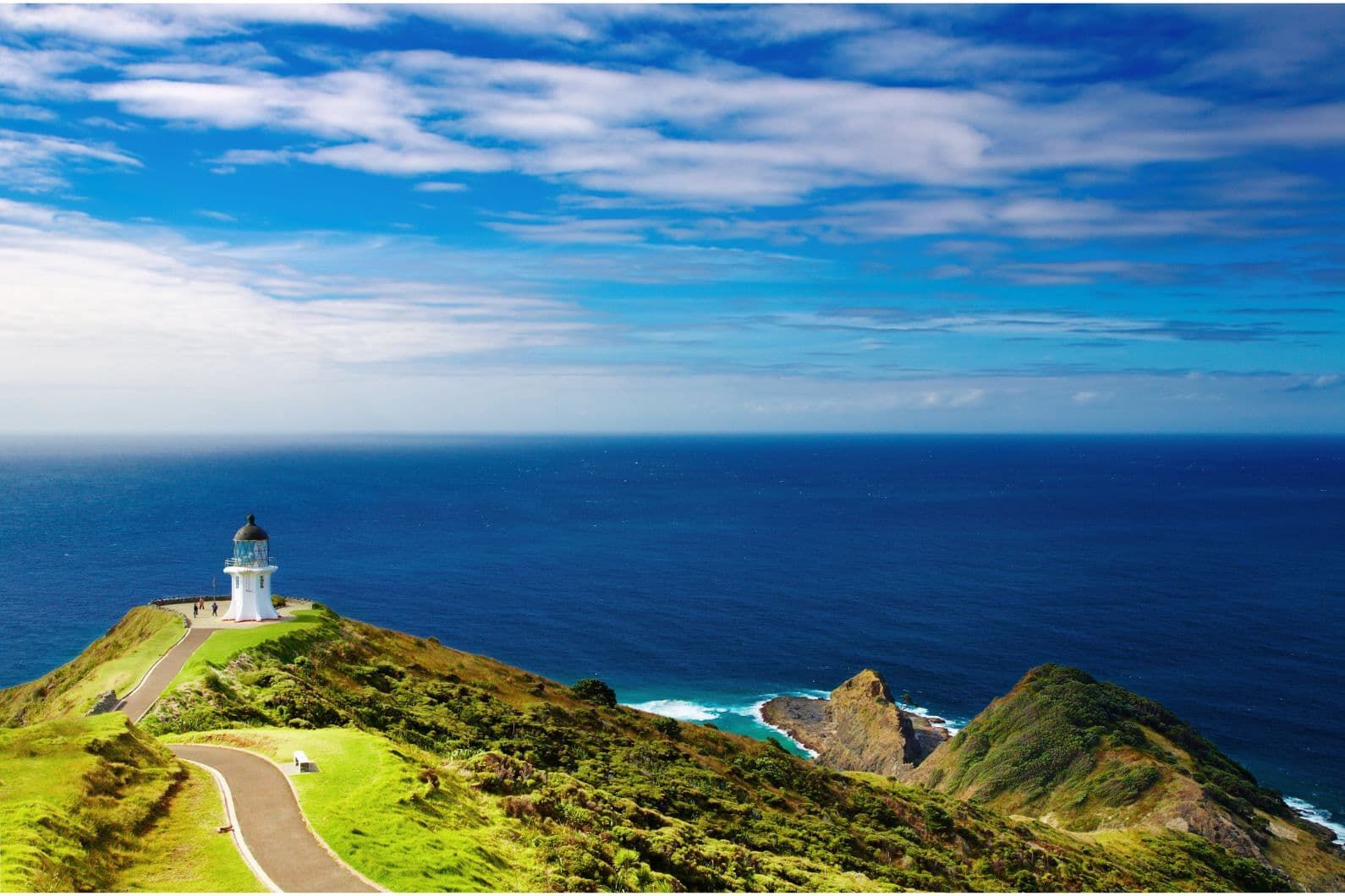
The current Cape Reinga Lighthouse was built in 1941 and moved from Motuopao Island to the mainland for easier access and maintenance. It now stands on a small headland below the main car park with views toward Cape Maria van Diemen and Spirits Bay. Although the light was fully automated in 1987, it remains an iconic waypoint for ships at the very top of the country and one of the most photographed lighthouses in New Zealand.
The short, sealed path from the car park to the lighthouse is an easy walk suitable for most ages; interpretive panels along the way explain local history, navigation facts and cultural stories.
Read more: The Best Lighthouses in New Zealand to Photograph
Walking tracks at the Cape
Beyond the main lighthouse path, DOC manages longer coastal tracks which form part of Te Paki Coastal Track and the Te Araroa long-distance trail. Options include:
- Short side paths to lookouts with views of Spirits Bay and Cape Maria van Diemen.
- Multi-hour sections for experienced walkers that drop down to remote beaches. These require good fitness, planning and respect for changing weather and tides.
RaD Whangārei staff tip: If you are travelling with kids or have only a short window, focus on the main lighthouse path and one or two signed lookouts. If you want a longer coastal hike, talk to DOC or local operators in advance and build in plenty of daylight for your return.
Read more: New Zealand’s Best Hidden Gems You Won’t Find in Guidebooks
Māori legends and spiritual importance
Cape Reinga is not just scenic; it is one of the most sacred places in Aotearoa. In Māori belief, this is where the spirits of the dead come to begin their final journey to Hawaiki, the ancestral homeland.
According to tradition:
- Spirits travel north along the coast to Te Rerenga Wairua and descend the cliff via the roots of an ancient pōhutukawa tree believed to be around 800 years old.
- They move underwater to the Three Kings Islands, pause to look back at the land one last time, then continue on to the underworld.
This makes the headland a living urupā (burial ground) in spiritual terms, not a beach picnic spot. Guidance from iwi and DOC asks visitors to treat the area with respect; that means staying on formed paths, keeping voices low near the headland and avoiding food right beside the lighthouse.
RaD Auckland West tip: Staff often remind visitors that Cape Reinga is both a tourist highlight and a wāhi tapu (sacred place). Enjoy your photos and views, but make your main picnic stop at Tapotupotu Bay or another nearby beach instead of at the very tip.
Te Paki Sand Dunes and Ninety Mile Beach
A Cape Reinga itinerary works best when you combine the headland with nearby coastal adventures.
Te Paki Sand Dunes

The Te Paki Sand Dunes rise up to around 150 metres high and form a striking desert-like landscape only a few minutes off State Highway 1. To reach them, you turn onto Te Paki Stream Road from SH1, then follow it for about 3 kilometres to a car park beside a shallow stream.
Once there, you can walk up onto the dunes for sweeping views across the valley. Many visitors hire sandboards from operators at the car park for high-speed descents, although DOC notes that sandboarding carries real risk and should be approached cautiously.
Ninety Mile Beach

Ninety Mile Beach stretches for about 88 kilometres along the west coast of the Far North and is officially designated as a public highway, although it is only suitable for experienced drivers in appropriate 4WD vehicles and in safe tide and weather conditions. Many visitors choose to experience the beach on coach tours that drive along the sand and up Te Paki Stream, leaving them free to enjoy the scenery without worrying about tides or soft spots.
For independent travellers in standard rental cars, the safest option is to park at designated access points such as those near Ahipara or the Te Paki Dunes, then walk along the beach without taking your vehicle onto the sand or into Te Paki Stream. DOC is clear that Te Paki Stream is open to 4WD vehicles only.
RaD Whangārei staff tip: RaD standard rental cars are not insured for driving on beaches or through streams, so it’s best to park at official car parks, walk or join a guided tour if you want the full Ninety Mile Beach experience and keep your vehicle on sealed or well formed gravel roads.
Planning your NZ road trip to Cape Reinga
Distances and suggested bases
- Auckland to Cape Reinga is roughly a 5-hour drive one way in good conditions, so it works best as part of a multi-day Northland road trip with overnight stops.
- Whangārei to Cape Reinga takes about 3.5 to 4 hours via SH1 and SH10 or SH1 through Kaitaia, depending on your route.
- Kaitaia or Doubtless Bay areas (such as Coopers Beach or Cable Bay) make excellent bases for a full-day loop to the Cape with time for dunes and beach walks.
RaD Auckland Airport tip: Many visitors pick up a car at the airport, drive to Paihia or Kerikeri on day one, then head to Cape Reinga on day two from a Far North base. This keeps individual driving legs to 3 to 4 hours, which is more comfortable, especially if you are adjusting to driving on the left.
Places to eat and refuel
- Food and fuel are limited right at the top, so staff recommend filling your tank in Kaitaia, Awanui or Mangonui and stocking up on snacks and water before the final stretch north.
- Classic stops on SH10 include Mangonui for fish and chips over the water and small cafes in Coopers Beach or Taipa.
- On SH1, Awanui and Kaitaia offer supermarkets, bakeries and petrol stations. Grab picnic supplies there to enjoy at Tapotupotu or Spirits Bay camps and picnic areas.
RaD Auckland West tip: Northland temperatures can be warmer and more humid than you expect - carry extra water in the car, keep sunscreen handy and aim to hike lighthouse tracks early or late in the day in summer.
Embracing New Zealand Life - slower stops and lesser-known bays
Many tour brochures rush visitors to the lighthouse, dunes and back, but having a rental car means you can add quieter spots that most day tours miss.

Ideas from RaD staff and regulars include:
- Tapotupotu Bay for a swim and picnic in a sheltered cove just east of Cape Reinga. DOC maintains a campground here that is popular with self-drive travellers.
- Spirits Bay (Kapowairua) for long walks along a curved white sand beach with strong spiritual associations and fewer crowds than Ninety Mile Beach.
- Doubtless Bay’s Coopers Beach, Cable Bay and Taipa for gentler swimming and golden hour photography on your way to or from the Far North.
These stops turn Cape Reinga from a single tick box into a richer Northland journey that balances driving time with time on the sand, in the water and on short tracks.
Hiring a Car for Northland Adventures
Northland is one of New Zealand’s most popular tourist destinations, and for good reason. From beautiful white sandy beaches, to turquoise water bays, to the wow factor of two oceans colliding, Northland has a lot to offer travellers of all ages.
Many people fly into Auckland before starting their journey further north although local domestic flights can also get you to Whangarei if you want to shorten your driving distance.
The good news for you is that RaD Car Hire, with 22 branches nationwide, has you well covered for your Northland adventure. With two branches in Auckland – one at the airport and one in West Auckland, plus an option for pick up and drop off at Auckland City hotels and accommodation – we have the best deals on car hire in Auckland to get you on the road and exploring our beautiful country.
If you decide to take a regional flight further north, Whangarei is a great starting point and our team up in Whangarei will be delighted to get you on the road, as well as providing you with some amazing local tips for exploring Northland.
For more ideas on things to do in Northland, make sure you check out our guide for things to do in Northland and if you are planning a bigger New Zealand adventure, check out all our travel guides for ideas on things to do, places to visit, where to stay and places to eat.
FAQs - Exploring Cape Reinga
Is Cape Reinga really the northernmost point of New Zealand?
Strictly speaking the North Cape area and Surville Cliffs lie slightly further north, but Cape Reinga is the northernmost point that is easily accessible by road and is widely treated as the symbolic top of New Zealand for travellers.
Can you actually see the Tasman Sea and Pacific Ocean meet?
On many days, you can see visible lines and patches of different coloured water and wave patterns colliding off the headland. This meeting of the Tasman Sea and the Pacific Ocean is one of the main reasons the site is so famous.
How long should I allow at Cape Reinga itself?
Most visitors spend 1 to 2 hours walking the main lighthouse path, reading interpretation panels and taking photos. If you add side lookouts or a short coastal section, plan for up to half a day before moving on to Te Paki Sand Dunes or nearby bays.
Is it safe to drive a rental on Ninety Mile Beach or Te Paki Stream?
Authorities and local advice make it clear that Te Paki Stream is for 4WD vehicles only and that beach driving carries real risks from soft sand and fast-moving tides. Most rental companies, including RaD, exclude beach and stream driving from insurance, so the safest option is to park at official access points and walk or join a guided tour.
Why is food and noise discouraged near the lighthouse area?
Cape Reinga or Te Rerenga Wairua is a highly sacred site where Māori believe spirits begin their final journey. Iwi guidance asks visitors to treat the headland as a spiritual space rather than a picnic area, keeping food for nearby beaches and speaking quietly near the tip.